Powering a greener future
What Is the Proposed Bretherton Energy Partnership?

The Bretherton Energy Partnership is exploring the installation of a wind turbine and solar panels to generate zero-carbon electricity for residents and local businesses.

Five per cent of the wind and solar electricity generated would be supplied to the community via a cable that runs to Bretherton’s electricity substations.

A battery system would be required to help balance variable wind and solar generation with residents’ consumption, and also for regulatory and grid-compliance purposes.

Any surplus electricity from the residents’ five per cent allocation would be sold to GA Pet Food or the National Grid to generate income that could then be invested in local community projects.

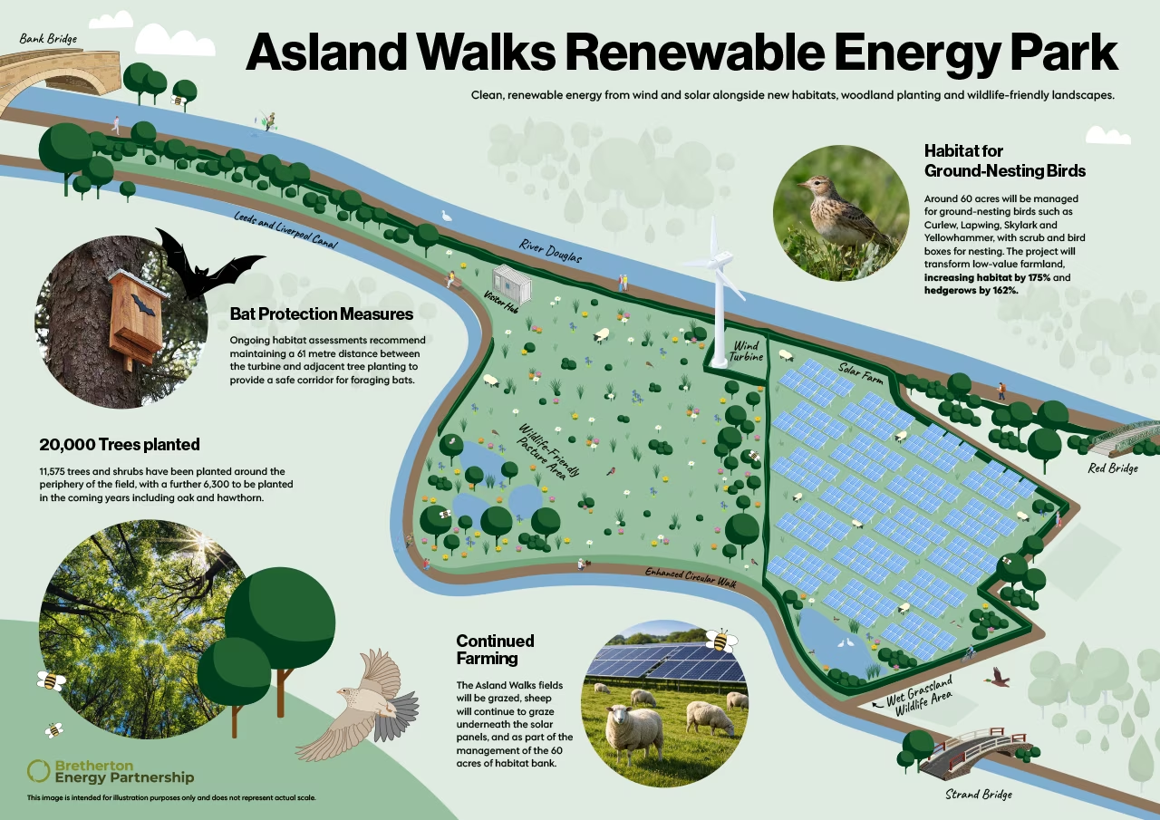
The Asland Walks Energy Park, located between the River Douglas and the Leeds and Liverpool Canal, would include a 4.2 MW wind turbine, a solar panel field, and a battery system.
Where Would the Wind Turbine and Solar Field Be?
The Asland Walks Renewable Energy Park would consist of a single wind turbine and a solar field situated between the River Douglas and the Leeds and Liverpool Canal.
The proposed Energy Park covers approximately 100 acres of arable land and will be accessible to the community. Planned future ecological improvements include:
- Tree planting: To date, 11,575 trees and shrubs have been planted around the edge of the field, with a further 6,300 planned in the coming years.
- Visitor centre: This will provide information about the Energy Park, how it works, and live generation data.
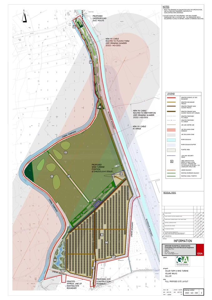
Below is a potential layout containing both wind turbines and solar panels. East–west aligned solar panels increase electrical energy yield compared with south-facing panels. The east–west layout captures solar energy over a longer portion of the day, which helps to flatten the peaks in generation.
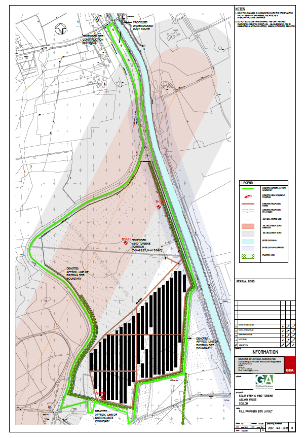
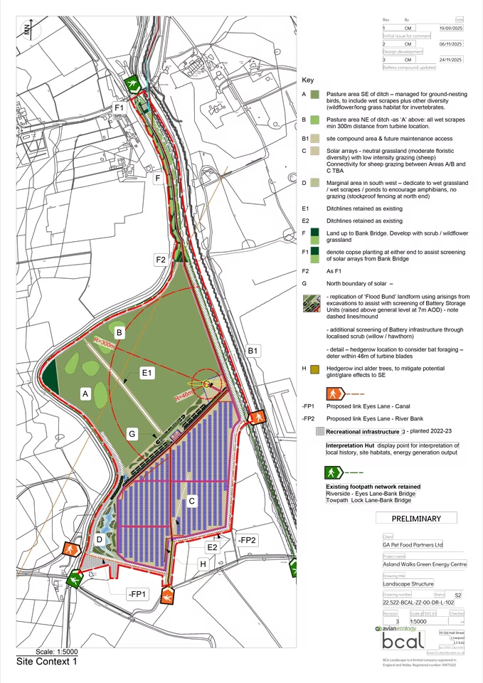
The site layout drawing shows the proposed areas for the solar array and the wind turbine. The locations have been selected to ensure minimal impact on several identified factors.
In line with recent Ministerial Guidance on the protection of the best and most versatile agricultural land (Grades 1, 2, and 3a), all solar panels are proposed to be installed on lower-grade (3b) soil. This ensures that the best agricultural land is preserved and also allows space for further ecological enhancement.
Wind monitoring has now been completed over a 36-month period. The average wind speed at 111 metres height is 7.3 m/s, which indicates that the proposed turbine would operate efficiently and generate optimum energy for the partnership. A solar monitoring station has also been installed to measure on-site solar energy potential and ensure appropriate equipment selection.
In addition, benches, bins, and picnic benches have been installed around Asland Walks Energy Park, providing rest points for walkers. A further two benches will be installed on the eastern side overlooking the River Douglas.
Wind Turbine Location
The wind turbine, located on the eastern section of the field, has been sited here based on several key considerations:
- A detailed telecommunications assessment by JRC Communication Ltd identified a local telecommunications link that requires a significant easement within the park. This largely rules out development in the northern, eastern, and southern areas of the Energy Park.
- The turbine will be positioned at least 500 metres from the nearest residence. Although not required by legislation, and noise assessments show no harmful impact, the Bretherton Energy Partnership wishes to demonstrate best practice.
- Ongoing habitat assessments recommend maintaining a 61 metre distance between the turbine and adjacent tree planting to provide a safe corridor for foraging bats.
- A regulatory easement is required from both the River Douglas and the site boundary.
Why Decrease The Height?
The previously proposed turbine height was 200 metres to the blade tip.
Following a detailed assessment, the aviation consultant advised that BAE Warton required additional height tolerance above 200 metres due to potential interference with instrument flight procedures. A 200 metre turbine would provide minimal tolerance, increasing the likelihood of a formal objection. Lowering the turbine base by 4.2 metres would have met the requirement but left no safety margin and created structural design complications.
This led to the Bretherton Energy Partnership agreeing to reduce the turbine height to 180 metres (blade tip). The impacts are summarised below.